


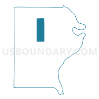
RIDGWAY 1 Voting District, Gallatin County, Illinois
About
Outline

Summary
| Unique Area Identifier | 570997 |
| Name | RIDGWAY 1 Voting District |
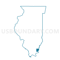
| County | Gallatin County |
| State | Illinois |
| Area (square miles) | 11.43 |
| Land Area (square miles) | 11.43 |
| Water Area (square miles) | 0.00 |
| % of Land Area | 99.96 |
| % of Water Area | 0.04 |
| Latitude of the Internal Point | 37.82169870 |
| Longtitude of the Internal Point | -88.24127380 |
Maps

Graphs
Select a template below for downloading or customizing gragh for RIDGWAY 1 Voting District, Gallatin County, Illinois


Neighbors
Neighoring Voting District (by Name) Neighboring Voting District on the Map
- ASBURY Voting District, Gallatin County, IL
- EQUALITY Voting District, Gallatin County, IL
- GOLD HILL 1 Voting District, Gallatin County, IL
- NORTH FORK Voting District, Gallatin County, IL
- OMAHA Voting District, Gallatin County, IL
- RIDGWAY 2 Voting District, Gallatin County, IL
Top 10 Neighboring County Subdivision (by Population) Neighboring County Subdivision on the Map
- Gold Hill township, Gallatin County, IL (1,708)
- Ridgway township, Gallatin County, IL (937)
- Equality township, Gallatin County, IL (849)
- Omaha township, Gallatin County, IL (499)
- North Fork township, Gallatin County, IL (408)
- Asbury township, Gallatin County, IL (105)